Operations
Availability
The standard availability is 24 hours a day 365 days per year, although there are periods when the aircraft is taken out of service for maintenance reasons.
The Service will operate in darkness and adverse weather. In addition to its visual search capability, the aircraft is fitted with a Wescam MX10 IR turret, Koden marine radar, Rotheta multi-frequency homer and search lights to assist the crew at night or in conditions of poor visibility. We use TZ Professional navigation software for marine searches and AIMS-HD mission management software for searches of all types, especially land based searches.
Call-out Procedure
The status of a call-out is colour coded as follows:-
(i) Air Search Red
The crew are to be called for immediate service and will proceed to take-off without further instructions.
(ii) Air Search Yellow
The crew are called to immediate readiness and will prepare for take-off up to the point of starting engines but will then await further instructions.
Air Search call-outs may be initiated by the authorities in the Channel Islands, France and the United Kingdom, including Coastguard, Air Traffic Control, the Police or Fire services. The Service provides its aircraft and crews without charge.
Normal Guernsey airport hours are 0600 to 2100 (local time) seven days a week although it is closed on 25 December. Outside normal operating hours, if required, the Airport will be opened to permit the Air Search aircraft (and ambulance flights or other SAR aircraft) to operate for emergencies.
Time to readiness
The operational target adopted by the Service is that the aircraft be ready to start engines within 35 minutes of the crew receiving a call-out.
Area of Operations & Time to Search
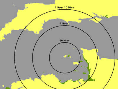 The following diagram shows the normal area covered by the Service (amounting to some 4,000 square miles). The diagram also displays the approximate time required for the aircraft to arrive at the point of search. It includes the time required for call-out plus the still air time to reach a given distance from Guernsey airport.
Rates of Search
(i) Speed
The average speed of the search aircraft will be either 90 knots for a close search or 120 knots for a sweep of an area.
(ii) Search Endurance
The normal search endurance of the aircraft is 3 hours 30 minutes (with reserves of one hour).
Where possible, the aircraft will return to Guernsey to refuel; as this enables a crew change to be made, but circumstances may require a landing at the nearest point to the search.
(iii) Track Spacing
The choice of track spacing greatly varies the area which can be covered in the time available
Track spacing should not normally be greater than one half of the horizontal visibility available to the crew of the aircraft.
Search for a Person
As a guide, a search for a person or small debris should be flown at track spacings of not more than 0.25 nautical miles (400 metres).
Search for a Small Vessel or Aircraft
A search for either of the above requires a track spacing of not greater than 2 nautical miles.
Search for a Large Vessel or Pollution
A search for either of the above requires a track spacing of between 2 nautical miles and 4 nautical miles depending upon weather conditions.
Search Height
The lowest practical height for a search is 250 feet above the sea, when looking for a person or small objects.
A search for a vessel will normally be flown at about 500 feet, depending upon track spacing, weather conditions and size of the target. Searches using FLIR will be flown at a height suitable for the camera scan and will normally be between 1,000 feet and 3,000 feet.
Communications
The aircraft carries two full 720 channel aeronautical VHF radios.
The marine VHF radio is multi-channel and includes channels 0, 11, 13, 16 and most other frequencies.
We also carry Tetra radios for land based searches to allow secure communications with the Police and the Civil Protection teams.
Mobile telephones can be attached by bluetooth to our headsets as necessary.
Navigation
The primary search aid is a differential Global Positioning System (GPS). When using this facility, the aircraft will normally search in the most favourable direction, taking account of drift and glare. The GPS drives a purpose designed SAR software package which presents the Search Director with a computer driven TimeZero marine charts with the Manche Grid overlay on which is superimposed the desired search pattern and other features, such as direction of tidal flow. The position of the aircraft and its track are continually updated and recorded to disk for later evaluation. A repeater presents track-keeping information directly to the Pilot.

Radar
The aircraft is fitted with a 24-mile search radar. This facility enables a radar sweep of a 4-mile corridor to be undertaken in conditions of darkness or low visibility, and the effectiveness is directly proportional to the amount of "clutter" from wave action. A search downwind is more likely to be effective than a search upwind or across the wind.

Homer
Search for the source of an ELT or EPIRB homer or a vessel transmitting is carried out by use of the aircraft's homing system, which operates on AM 121.5 MHz, 243 MHz, 406 MHz and FM Ch 16.
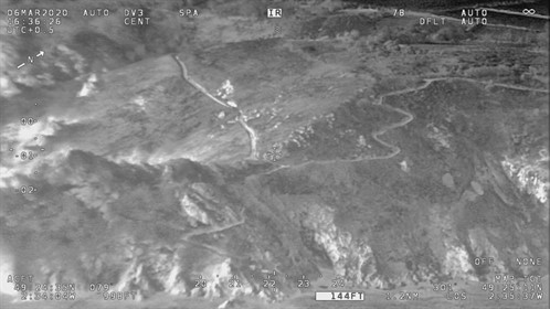
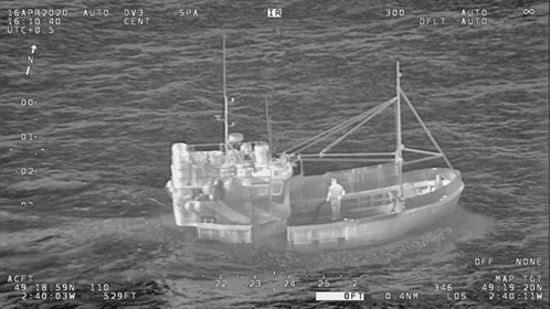
Thermal Imaging Equipment ("FLIR")
The aircraft is equipped with a Wescam MX-10 camera, which gives both a greatly increased night time search capability and allows the search for a heat source (when persons or objects have a temperature difference from their surroundings).

The FLIR camera is particularly valuable in searching for persons lost at sea, and is also of assistance to Police and Fire services in searching for missing persons or establishing the location of the likely seat of a fire, particularly on board a vessel.
The equipment (which is third generation) can be of help when other means of searching (for example, visually or by radar) cannot be accomplished with complete effectiveness. The camera array includes a broadcast quality video lens with high telephoto capabilities. This allows for the early identification of distant targets.
Two pairs of monitors are fitted to the aircraft, one in the middle row, the other in the FLIR operator's console. Either the Search Director, but mainly the FLIR trained operator can control the camera. An aviation video recorder preserves the film footage (either infra red or video) for future use.

In conditions of good visibility, the crew will normally conduct a visual search, using FLIR as an aid to identifying specific targets. In conditions of low light, or where searching for persons, the search will most probably be conducted using thermal imaging, in which event the aircraft will probably operate at a height of not below 600 feet and as high as conditions dictate, but not normally above 2,000 feet.
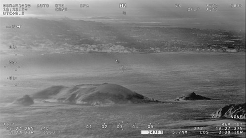
This is a view of Jethou looking towards Guernsey using the FLIR Camera on our new aircraft during a recent training flight.
The images below show the various heat sources that the search crew use to try and identify any missing persons both on land and in the water.